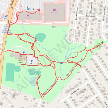
Thank you for supporting this site ❤️
Make a donation
Make a donation
Gear up for your next adventure:
As an Amazon Associate, this site earns from qualifying purchases at no extra cost to you.
Catonsville Park
- Distance: 2.6 mi
- Elevation gain: 128 ft
- Maximum elevation: 525 ft
- Elevation loss: 135 ft
- Minimum elevation: 482 ft
- Moving time: 50 m 13 s
- Moving speed: 3.1 mph
- Maximum speed: 14.3 mph
- Total time: 50 m 13 s
- Global speed: 3.1 mph
Interactive trail map
Thank you for supporting this site ❤️
Make a donation
Make a donation
Gear up for your next adventure:
As an Amazon Associate, this site earns from qualifying purchases at no extra cost to you.
Trail profile
- Distance: 2.6 mi
- Elevation gain: 128 ft
- Maximum elevation: 525 ft
- Elevation loss: 135 ft
- Minimum elevation: 482 ft
- Moving time: 50 m 13 s
- Moving speed: 3.1 mph
- Maximum speed: 14.3 mph
- Total time: 50 m 13 s
- Global speed: 3.1 mph
Thank you for supporting this site ❤️
Make a donation
Make a donation
Gear up for your next adventure:
As an Amazon Associate, this site earns from qualifying purchases at no extra cost to you.
About this trail
Name: Catonsville Park trail, distance, elevation, map, profile, GPS track
Coordinates: 39.27730 -76.75452 39.28185 -76.74794
Topography: Baltimore County topographic map, elevation, terrain
Thank you for supporting this site ❤️
Make a donation
Make a donation
Gear up for your next adventure:
As an Amazon Associate, this site earns from qualifying purchases at no extra cost to you.