Thank you for supporting this site ❤️
Make a donation
Make a donation
Gear up for your next adventure:
As an Amazon Associate, this site earns from qualifying purchases at no extra cost to you.
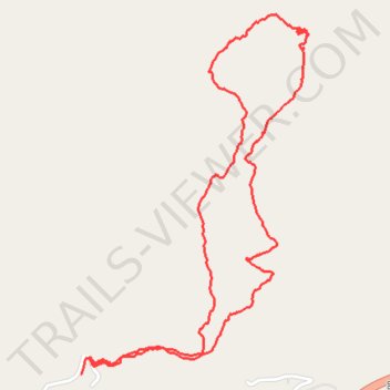
Lucy Braun Memorial Trail
- Distance: 3.6 mi
- Elevation gain: 1,037 ft
- Maximum elevation: 2,362 ft
- Elevation loss: 1,024 ft
- Minimum elevation: 1,385 ft
- Moving time: 1 h 28 m
- Moving speed: 2.5 mph
- Maximum speed: 13.3 mph
- Total time: 1 h 43 m
- Global speed: 2.1 mph
Interactive trail map
Thank you for supporting this site ❤️
Make a donation
Make a donation
Gear up for your next adventure:
As an Amazon Associate, this site earns from qualifying purchases at no extra cost to you.
Trail profile
- Distance: 3.6 mi
- Elevation gain: 1,037 ft
- Maximum elevation: 2,362 ft
- Elevation loss: 1,024 ft
- Minimum elevation: 1,385 ft
- Moving time: 1 h 28 m
- Moving speed: 2.5 mph
- Maximum speed: 13.3 mph
- Total time: 1 h 43 m
- Global speed: 2.1 mph
Thank you for supporting this site ❤️
Make a donation
Make a donation
Gear up for your next adventure:
As an Amazon Associate, this site earns from qualifying purchases at no extra cost to you.
About this trail
Name: Lucy Braun Memorial Trail trail, distance, elevation, map, profile, GPS track
Start: Camp Blanton Lane, Harlan County, Kentucky, 40824, United States (36.86128 -83.37951)
End: Camp Blanton Lane, Harlan County, Kentucky, 40824, United States (36.86191 -83.37904)
Coordinates: 36.86128 -83.37951 36.87511 -83.36858
Topography: Harlan County topographic map, elevation, terrain
Thank you for supporting this site ❤️
Make a donation
Make a donation
Gear up for your next adventure:
As an Amazon Associate, this site earns from qualifying purchases at no extra cost to you.