Thank you for supporting this site ❤️
Make a donation
Make a donation
Gear up for your next adventure:
As an Amazon Associate, this site earns from qualifying purchases at no extra cost to you.
Manning Canyon Exploration
Cycling
- Distance: 23.6 mi
- Elevation gain: 2,867 ft
- Maximum elevation: 7,044 ft
- Elevation loss: 2,861 ft
- Minimum elevation: 4,977 ft
- Moving time: 3 h 17 m
- Moving speed: 7.2 mph
- Maximum speed: 31.6 mph
- Total time: 3 h 42 m
- Global speed: 6.4 mph
Interactive trail map
Thank you for supporting this site ❤️
Make a donation
Make a donation
Gear up for your next adventure:
As an Amazon Associate, this site earns from qualifying purchases at no extra cost to you.
Trail profile
- Distance: 23.6 mi
- Elevation gain: 2,867 ft
- Maximum elevation: 7,044 ft
- Elevation loss: 2,861 ft
- Minimum elevation: 4,977 ft
- Moving time: 3 h 17 m
- Moving speed: 7.2 mph
- Maximum speed: 31.6 mph
- Total time: 3 h 42 m
- Global speed: 6.4 mph
Thank you for supporting this site ❤️
Make a donation
Make a donation
Gear up for your next adventure:
As an Amazon Associate, this site earns from qualifying purchases at no extra cost to you.
About this trail
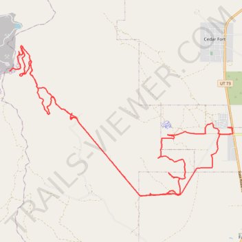
Name: Manning Canyon Exploration trail, distance, elevation, map, profile, GPS track
Coordinates: 40.27560 -112.19527 40.32488 -112.09892
Topography: Utah County topographic map, elevation, terrain
Thank you for supporting this site ❤️
Make a donation
Make a donation
Gear up for your next adventure:
As an Amazon Associate, this site earns from qualifying purchases at no extra cost to you.