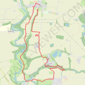
Beckbury Badger Cicular walk
- Distance: 6.2 mi
- Elevation gain: 351 ft
- Maximum elevation: 325 ft
- Elevation loss: 377 ft
- Minimum elevation: 151 ft
- Moving time: 3 h 5 m
- Moving speed: 2.0 mph
- Maximum speed: 8.8 mph
- Total time: 3 h 43 m
- Global speed: 1.7 mph
Interactive trail map
Trail profile
- Distance: 6.2 mi
- Elevation gain: 351 ft
- Maximum elevation: 325 ft
- Elevation loss: 377 ft
- Minimum elevation: 151 ft
- Moving time: 3 h 5 m
- Moving speed: 2.0 mph
- Maximum speed: 8.8 mph
- Total time: 3 h 43 m
- Global speed: 1.7 mph
About this trail
Name: Beckbury Badger Cicular walk trail, distance, elevation, map, profile, GPS track
Start: Madeley Lane, Beckbury, Shropshire, England, TF11 9DF, United Kingdom (52.61028 -2.34944)
End: Madeley Lane, Beckbury, Shropshire, England, TF11 9DF, United Kingdom (52.61155 -2.34837)
Coordinates: 52.58616 -2.35907 52.61211 -2.33509
Other hiking, mountain biking, running and outdoor activity trails
Click on a trail to view its statistics, map and profile.
Walk around Badger Dingle
United Kingdom > England > Shropshire > Badger
Distance: 2.9 mi • Elevation gain: 154 ft • Maximum elevation: 249 ft