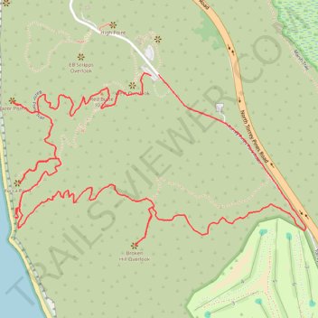
Torrey Pines State Natural Reserve Loop
Loop hike via Razor Point, Yucca Point and Broken Hill #Hiking #Coast #Pacific #Ocean #Sea
- Distance: 3.4 mi
- Elevation gain: 587 ft
- Maximum elevation: 394 ft
- Elevation loss: 597 ft
- Minimum elevation: 33 ft
- Moving time: 1 h 16 m
- Moving speed: 2.7 mph
- Maximum speed: 3.6 mph
- Total time: 1 h 23 m
- Global speed: 2.5 mph
Interactive trail map
Trail profile
- Distance: 3.4 mi
- Elevation gain: 587 ft
- Maximum elevation: 394 ft
- Elevation loss: 597 ft
- Minimum elevation: 33 ft
- Moving time: 1 h 16 m
- Moving speed: 2.7 mph
- Maximum speed: 3.6 mph
- Total time: 1 h 23 m
- Global speed: 2.5 mph
About this trail
Name: Torrey Pines State Natural Reserve Loop trail, distance, elevation, map, profile, GPS track
Coordinates: 32.91375 -117.25853 32.91986 -117.24613
Topography: San Diego topographic map, elevation, terrain
Other hiking, mountain biking, running and outdoor activity trails
Click on a trail to view its statistics, map and profile.
Torrey Pines State Natural Reserve Loop via Guy Flemming Trail, EB Scripps Overlook, Razor Point, Yucca Point and Beach trails
United States > California > San Diego County > San Diego
Embarking on the Torrey Pines State Natural Reserve Loop via the Guy Fleming Trail, EB Scripps Overlook, Razor Point, Yucca Point and Beach trails offers hikers a diverse experience of Southern California's coastal beauty. Along the way, you'll encounter rare Torrey pine trees, dramatic sandstone cliffs, and…
Distance: 4.1 mi • Elevation gain: 801 ft • Maximum elevation: 335 ft
Razor Point, Yucca Point and Broken Hill Loop in Torrey Pines State Natural Reserve
United States > California > San Diego County > San Diego
The Razor Point, Yucca Point, and Broken Hill Loop in Torrey Pines State Natural Reserve offers hikers a captivating journey through diverse coastal landscapes. Along the trail, you'll encounter dramatic sandstone formations, expansive ocean vistas, and the unique Torrey pine trees, one of North America's…
Distance: 3.4 mi • Elevation gain: 564 ft • Maximum elevation: 394 ft
Torrey Pines Beach and Overlooks Loop
United States > California > San Diego County > San Diego
This loop hike is a delightful escape that beautifully combines stunning ocean views with charming paths. Inland, the path winds through picturesque overlooks like EB Scripps Overlook, West Overlook and Yucca Point, offering jaw-dropping ocean views. On the Beach, you'll have the chance to stroll on the sandy…
Distance: 3.1 mi • Elevation gain: 495 ft • Maximum elevation: 335 ft