Suntop Lookout
- Distance: 30.1 mi
- Elevation gain: 7,864 ft
- Maximum elevation: 5,210 ft
- Elevation loss: 4,613 ft
- Minimum elevation: 1,952 ft
- Moving time: 1 h 24 m
- Moving speed: 21.5 mph
- Maximum speed: 36.1 mph
- Total time: 1 h 42 m
- Global speed: 17.6 mph
Interactive trail map
Trail profile
- Distance: 30.1 mi
- Elevation gain: 7,864 ft
- Maximum elevation: 5,210 ft
- Elevation loss: 4,613 ft
- Minimum elevation: 1,952 ft
- Moving time: 1 h 24 m
- Moving speed: 21.5 mph
- Maximum speed: 36.1 mph
- Total time: 1 h 42 m
- Global speed: 17.6 mph
About this trail
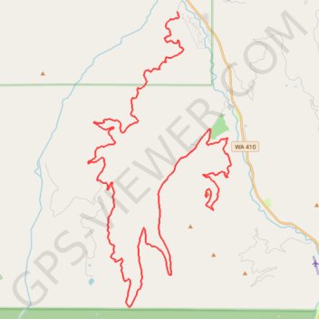
Name: Suntop Lookout trail, distance, elevation, map, profile, GPS track
End: Forest Road 7315, Pierce County, Washington, United States (47.04034 -121.59636)
Coordinates: 46.99633 -121.66559 47.11277 -121.58253
Topography: Pierce County topographic map, elevation, terrain
Other hiking, mountain biking, running and outdoor activity trails
Click on a trail to view its statistics, map and profile.
Northern part of the Pacific Crest Trail (PCT)
United States > Oregon > Klamath County
Hike on the Pacific Crest National Scenic Trail from Crater Lake to Canada Border through Oregon and Washington along the Sierra Nevada and Cascade mountain ranges. #Hiking #Mountain #SierraNevada #Cascade #Nature #Forest #Park #PCT
Distance: 744.6 mi • Elevation gain: 145,367 ft • Maximum elevation: 7,569 ft