RE SK480600 2
- Distance: 0.5 mi
- Elevation gain: 23 ft
- Maximum elevation: 587 ft
- Elevation loss: 43 ft
- Minimum elevation: 558 ft
- Moving time: 17 m 45 s
- Moving speed: 1.8 mph
- Maximum speed: 5.1 mph
- Total time: 2 h 37 m
- Global speed: 0.2 mph
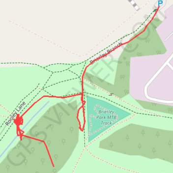
Interactive trail map
Trail profile
- Distance: 0.5 mi
- Elevation gain: 23 ft
- Maximum elevation: 587 ft
- Elevation loss: 43 ft
- Minimum elevation: 558 ft
- Moving time: 17 m 45 s
- Moving speed: 1.8 mph
- Maximum speed: 5.1 mph
- Total time: 2 h 37 m
- Global speed: 0.2 mph
About this trail
Name: RE SK480600 2 trail, distance, elevation, map, profile, GPS track
Coordinates: 53.13519 -1.28401 53.13737 -1.28072
Other hiking, mountain biking, running and outdoor activity trails
Click on a trail to view its statistics, map and profile.
RE SK480600
United Kingdom > England > Nottinghamshire > Ashfield > Sutton in Ashfield > Stanton Hill
Distance: 1.5 mi • Elevation gain: 138 ft • Maximum elevation: 600 ft
RE SK480600
United Kingdom > England > Nottinghamshire > Ashfield > Sutton in Ashfield > Stanton Hill
Distance: 0.7 mi • Elevation gain: 23 ft • Maximum elevation: 591 ft