Thank you for supporting this site ❤️
Make a donation
Make a donation
Gear up for your next adventure:
As an Amazon Associate, this site earns from qualifying purchases at no extra cost to you.
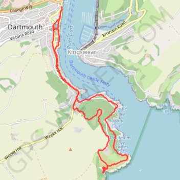
From Kingswear to Dartmouth
- Distance: 4.5 mi
- Elevation gain: 1,102 ft
- Maximum elevation: 344 ft
- Elevation loss: 1,102 ft
- Minimum elevation: 0 ft
- Moving time: 2 h 9 m
- Moving speed: 2.1 mph
- Maximum speed: 10.0 mph
- Total time: 2 h 26 m
- Global speed: 1.8 mph
Interactive trail map
Thank you for supporting this site ❤️
Make a donation
Make a donation
Gear up for your next adventure:
As an Amazon Associate, this site earns from qualifying purchases at no extra cost to you.
Trail profile
- Distance: 4.5 mi
- Elevation gain: 1,102 ft
- Maximum elevation: 344 ft
- Elevation loss: 1,102 ft
- Minimum elevation: 0 ft
- Moving time: 2 h 9 m
- Moving speed: 2.1 mph
- Maximum speed: 10.0 mph
- Total time: 2 h 26 m
- Global speed: 1.8 mph
Thank you for supporting this site ❤️
Make a donation
Make a donation
Gear up for your next adventure:
As an Amazon Associate, this site earns from qualifying purchases at no extra cost to you.
About this trail
Name: From Kingswear to Dartmouth trail, distance, elevation, map, profile, GPS track
Coordinates: 50.33364 -3.57860 50.35394 -3.56421
Thank you for supporting this site ❤️
Make a donation
Make a donation
Gear up for your next adventure:
As an Amazon Associate, this site earns from qualifying purchases at no extra cost to you.
Other hiking, mountain biking, running and outdoor activity trails
Click on a trail to view its statistics, map and profile.
Galmpton Stoke Fleming
United Kingdom > England > Torbay > Galmpton
Distance: 18.7 mi • Elevation gain: 2,674 ft • Maximum elevation: 617 ft