
Jajiktek Seawall Trail - Day 1
- Distance: 6.3 mi
- Elevation gain: 2,838 ft
- Maximum elevation: 1,444 ft
- Elevation loss: 1,499 ft
- Minimum elevation: 0 ft
- Moving time: 3 h 37 m
- Moving speed: 1.7 mph
- Maximum speed: 3.6 mph
- Total time: 8 h 7 m
- Global speed: 0.8 mph
Interactive trail map
Trail profile
- Distance: 6.3 mi
- Elevation gain: 2,838 ft
- Maximum elevation: 1,444 ft
- Elevation loss: 1,499 ft
- Minimum elevation: 0 ft
- Moving time: 3 h 37 m
- Moving speed: 1.7 mph
- Maximum speed: 3.6 mph
- Total time: 8 h 7 m
- Global speed: 0.8 mph
About this trail
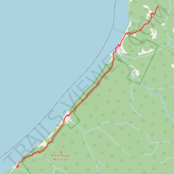
Name: Jajiktek Seawall Trail - Day 1 trail, distance, elevation, map, profile, GPS track
Coordinates: 46.87290 -60.74268 46.92760 -60.67215
Other hiking, mountain biking, running and outdoor activity trails
Click on a trail to view its statistics, map and profile.
Jajiktek Seawall Trail - Day 2
Canada > Nova Scotia > Municipality of the County of Inverness > Meat Cove > Red River
Distance: 3.7 mi • Elevation gain: 663 ft • Maximum elevation: 1,437 ft
Cape Breton Island - Pollets Cove
Canada > Nova Scotia > Municipality of the County of Inverness > Red River
Gulf of Saint Lawrence. #Hiking #CapeBreton #SaintLawrence #Atlantic
Distance: 8.6 mi • Elevation gain: 2,874 ft • Maximum elevation: 699 ft