Thank you for supporting this site ❤️
Make a donation
Make a donation
Gear up for your next adventure:
As an Amazon Associate, this site earns from qualifying purchases at no extra cost to you.
Lakewood
- Distance: 14.8 mi
- Elevation gain: 525 ft
- Maximum elevation: 1,109 ft
- Elevation loss: 525 ft
- Minimum elevation: 955 ft
- Moving time: 1 h 18 m
- Moving speed: 11.3 mph
- Maximum speed: 22.6 mph
- Total time: 1 h 27 m
- Global speed: 10.2 mph
Interactive trail map
Thank you for supporting this site ❤️
Make a donation
Make a donation
Gear up for your next adventure:
As an Amazon Associate, this site earns from qualifying purchases at no extra cost to you.
Trail profile
- Distance: 14.8 mi
- Elevation gain: 525 ft
- Maximum elevation: 1,109 ft
- Elevation loss: 525 ft
- Minimum elevation: 955 ft
- Moving time: 1 h 18 m
- Moving speed: 11.3 mph
- Maximum speed: 22.6 mph
- Total time: 1 h 27 m
- Global speed: 10.2 mph
Thank you for supporting this site ❤️
Make a donation
Make a donation
Gear up for your next adventure:
As an Amazon Associate, this site earns from qualifying purchases at no extra cost to you.
About this trail
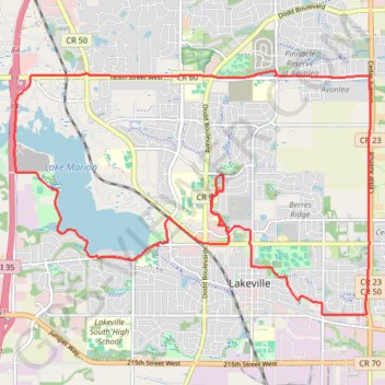
Name: Lakewood trail, distance, elevation, map, profile, GPS track
Coordinates: 44.64513 -93.29340 44.68235 -93.21731
Topography: Dakota County topographic map, elevation, terrain
Thank you for supporting this site ❤️
Make a donation
Make a donation
Gear up for your next adventure:
As an Amazon Associate, this site earns from qualifying purchases at no extra cost to you.