Thank you for supporting this site ❤️
Make a donation
Make a donation
Gear up for your next adventure:
As an Amazon Associate, this site earns from qualifying purchases at no extra cost to you.
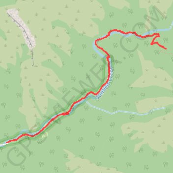
Smithfield Canyon Trail - Summit Creek
- Distance: 5.3 mi
- Elevation gain: 1,240 ft
- Maximum elevation: 7,221 ft
- Elevation loss: 1,253 ft
- Minimum elevation: 6,070 ft
- Moving time: 2 h 3 m
- Moving speed: 2.6 mph
- Maximum speed: 5.3 mph
- Total time: 2 h 38 m
- Global speed: 2.0 mph
Interactive trail map
Thank you for supporting this site ❤️
Make a donation
Make a donation
Gear up for your next adventure:
As an Amazon Associate, this site earns from qualifying purchases at no extra cost to you.
Trail profile
- Distance: 5.3 mi
- Elevation gain: 1,240 ft
- Maximum elevation: 7,221 ft
- Elevation loss: 1,253 ft
- Minimum elevation: 6,070 ft
- Moving time: 2 h 3 m
- Moving speed: 2.6 mph
- Maximum speed: 5.3 mph
- Total time: 2 h 38 m
- Global speed: 2.0 mph
Thank you for supporting this site ❤️
Make a donation
Make a donation
Gear up for your next adventure:
As an Amazon Associate, this site earns from qualifying purchases at no extra cost to you.
About this trail
Name: Smithfield Canyon Trail - Summit Creek trail, distance, elevation, map, profile, GPS track
Start: Smithfield Canyon Trail, Cache County, Utah, United States (41.88213 -111.72058)
End: Smithfield Canyon Road, Cache County, Utah, United States (41.88208 -111.72101)
Coordinates: 41.88205 -111.72101 41.89685 -111.69271
Topography: Cache County topographic map, elevation, terrain
Thank you for supporting this site ❤️
Make a donation
Make a donation
Gear up for your next adventure:
As an Amazon Associate, this site earns from qualifying purchases at no extra cost to you.