Thank you for supporting this site ❤️
Make a donation
Make a donation
Gear up for your next adventure:
As an Amazon Associate, this site earns from qualifying purchases at no extra cost to you.
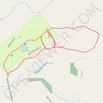
Whisky springs campground
- Distance: 1.1 mi
- Elevation gain: 79 ft
- Maximum elevation: 3,196 ft
- Elevation loss: 79 ft
- Minimum elevation: 3,127 ft
- Moving time: 24 m 54 s
- Moving speed: 2.6 mph
- Maximum speed: 9.1 mph
- Total time: 24 m 54 s
- Global speed: 2.6 mph
Interactive trail map
Thank you for supporting this site ❤️
Make a donation
Make a donation
Gear up for your next adventure:
As an Amazon Associate, this site earns from qualifying purchases at no extra cost to you.
Trail profile
- Distance: 1.1 mi
- Elevation gain: 79 ft
- Maximum elevation: 3,196 ft
- Elevation loss: 79 ft
- Minimum elevation: 3,127 ft
- Moving time: 24 m 54 s
- Moving speed: 2.6 mph
- Maximum speed: 9.1 mph
- Total time: 24 m 54 s
- Global speed: 2.6 mph
Thank you for supporting this site ❤️
Make a donation
Make a donation
Gear up for your next adventure:
As an Amazon Associate, this site earns from qualifying purchases at no extra cost to you.
About this trail
Name: Whisky springs campground trail, distance, elevation, map, profile, GPS track
Start: Whiskey Springs Campground, Jackson County, Oregon, United States (42.49891 -122.41391)
End: Whiskey Springs Campground, Jackson County, Oregon, United States (42.49894 -122.41399)
Coordinates: 42.49645 -122.41971 42.49903 -122.41317
Topography: Jackson County topographic map, elevation, terrain
Thank you for supporting this site ❤️
Make a donation
Make a donation
Gear up for your next adventure:
As an Amazon Associate, this site earns from qualifying purchases at no extra cost to you.