Thank you for supporting this site ❤️
Make a donation
Make a donation
Gear up for your next adventure:
As an Amazon Associate, this site earns from qualifying purchases at no extra cost to you.
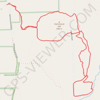
Hammond Hill trails Y7 Y8
- Distance: 4.6 mi
- Elevation gain: 702 ft
- Maximum elevation: 1,975 ft
- Elevation loss: 702 ft
- Minimum elevation: 1,549 ft
- Moving time: 1 h 19 m
- Moving speed: 3.5 mph
- Maximum speed: 6.8 mph
- Total time: 1 h 19 m
- Global speed: 3.5 mph
Interactive trail map
Thank you for supporting this site ❤️
Make a donation
Make a donation
Gear up for your next adventure:
As an Amazon Associate, this site earns from qualifying purchases at no extra cost to you.
Trail profile
- Distance: 4.6 mi
- Elevation gain: 702 ft
- Maximum elevation: 1,975 ft
- Elevation loss: 702 ft
- Minimum elevation: 1,549 ft
- Moving time: 1 h 19 m
- Moving speed: 3.5 mph
- Maximum speed: 6.8 mph
- Total time: 1 h 19 m
- Global speed: 3.5 mph
Thank you for supporting this site ❤️
Make a donation
Make a donation
Gear up for your next adventure:
As an Amazon Associate, this site earns from qualifying purchases at no extra cost to you.
About this trail
Name: Hammond Hill trails Y7 Y8 trail, distance, elevation, map, profile, GPS track
Coordinates: 42.42257 -76.30575 42.43726 -76.28725
Topography: Tompkins County topographic map, elevation, terrain
Thank you for supporting this site ❤️
Make a donation
Make a donation
Gear up for your next adventure:
As an Amazon Associate, this site earns from qualifying purchases at no extra cost to you.