Giba Gorge Mountain Bike trail, Honey Trails
Bicycle Tour
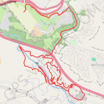
- Distance: 14.5 mi
- Elevation gain: 2,477 ft
- Maximum elevation: 2,110 ft
- Elevation loss: 2,477 ft
- Minimum elevation: 1,198 ft
- Moving time: 1 h 44 m
- Moving speed: 8.3 mph
- Maximum speed: 21.9 mph
- Total time: 1 h 49 m
- Global speed: 7.9 mph
Interactive trail map
Trail profile
- Distance: 14.5 mi
- Elevation gain: 2,477 ft
- Maximum elevation: 2,110 ft
- Elevation loss: 2,477 ft
- Minimum elevation: 1,198 ft
- Moving time: 1 h 44 m
- Moving speed: 8.3 mph
- Maximum speed: 21.9 mph
- Total time: 1 h 49 m
- Global speed: 7.9 mph
About this trail
Name: Giba Gorge Mountain Bike trail, Honey Trails trail, distance, elevation, map, profile, GPS track
Coordinates: -29.82649 30.76128 -29.79977 30.78224