Thank you for supporting this site ❤️
Make a donation
Make a donation
Gear up for your next adventure:
As an Amazon Associate, this site earns from qualifying purchases at no extra cost to you.
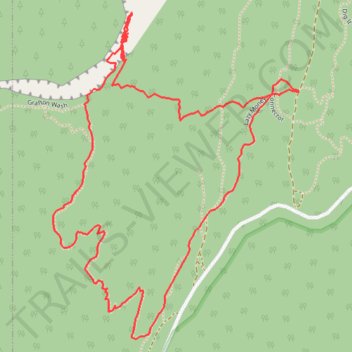
Grafton Wash Springs
- Distance: 2.3 mi
- Elevation gain: 502 ft
- Maximum elevation: 4,839 ft
- Elevation loss: 502 ft
- Minimum elevation: 4,416 ft
- Moving time: 1 h 22 m
- Moving speed: 1.7 mph
- Maximum speed: 3.4 mph
- Total time: 2 h 58 m
- Global speed: 0.8 mph
Interactive trail map
Thank you for supporting this site ❤️
Make a donation
Make a donation
Gear up for your next adventure:
As an Amazon Associate, this site earns from qualifying purchases at no extra cost to you.
Trail profile
- Distance: 2.3 mi
- Elevation gain: 502 ft
- Maximum elevation: 4,839 ft
- Elevation loss: 502 ft
- Minimum elevation: 4,416 ft
- Moving time: 1 h 22 m
- Moving speed: 1.7 mph
- Maximum speed: 3.4 mph
- Total time: 2 h 58 m
- Global speed: 0.8 mph
Thank you for supporting this site ❤️
Make a donation
Make a donation
Gear up for your next adventure:
As an Amazon Associate, this site earns from qualifying purchases at no extra cost to you.
About this trail
Name: Grafton Wash Springs trail, distance, elevation, map, profile, GPS track
Start: Connector, Washington County, Utah, United States (37.13361 -113.09804)
End: Connector, Washington County, Utah, United States (37.13360 -113.09807)
Coordinates: 37.12760 -113.10556 37.13553 -113.09804
Topography: Washington County topographic map, elevation, terrain
Thank you for supporting this site ❤️
Make a donation
Make a donation
Gear up for your next adventure:
As an Amazon Associate, this site earns from qualifying purchases at no extra cost to you.