Thank you for supporting this site ❤️
Make a donation
Make a donation
Gear up for your next adventure:
As an Amazon Associate, this site earns from qualifying purchases at no extra cost to you.
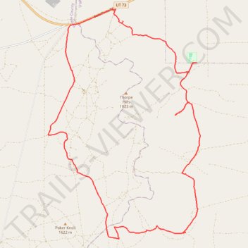
Thorpe Hills Cycling Loop
- Distance: 19.3 mi
- Elevation gain: 1,503 ft
- Maximum elevation: 5,443 ft
- Elevation loss: 1,506 ft
- Minimum elevation: 4,948 ft
- Moving time: 2 h 19 m
- Moving speed: 8.3 mph
- Maximum speed: 25.1 mph
- Total time: 2 h 25 m
- Global speed: 8.0 mph
Interactive trail map
Thank you for supporting this site ❤️
Make a donation
Make a donation
Gear up for your next adventure:
As an Amazon Associate, this site earns from qualifying purchases at no extra cost to you.
Trail profile
- Distance: 19.3 mi
- Elevation gain: 1,503 ft
- Maximum elevation: 5,443 ft
- Elevation loss: 1,506 ft
- Minimum elevation: 4,948 ft
- Moving time: 2 h 19 m
- Moving speed: 8.3 mph
- Maximum speed: 25.1 mph
- Total time: 2 h 25 m
- Global speed: 8.0 mph
Thank you for supporting this site ❤️
Make a donation
Make a donation
Gear up for your next adventure:
As an Amazon Associate, this site earns from qualifying purchases at no extra cost to you.
About this trail
Name: Thorpe Hills Cycling Loop trail, distance, elevation, map, profile, GPS track
Start: Thorpe Flats, Utah County, Utah, United States (40.23578 -112.16248)
End: Thorpe Flats, Utah County, Utah, United States (40.23589 -112.16252)
Coordinates: 40.15715 -112.19178 40.23618 -112.12318
Topography: Utah County topographic map, elevation, terrain
Thank you for supporting this site ❤️
Make a donation
Make a donation
Gear up for your next adventure:
As an Amazon Associate, this site earns from qualifying purchases at no extra cost to you.