Thank you for supporting this site ❤️
Make a donation
Make a donation
Gear up for your next adventure:
As an Amazon Associate, this site earns from qualifying purchases at no extra cost to you.
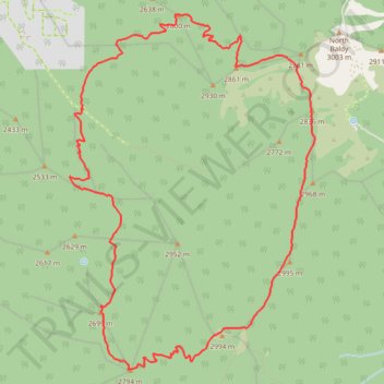
Cibola National Forest hike
- Distance: 9.2 mi
- Elevation gain: 2,766 ft
- Maximum elevation: 9,862 ft
- Elevation loss: 2,766 ft
- Minimum elevation: 7,756 ft
- Moving time: 4 h 22 m
- Moving speed: 2.1 mph
- Maximum speed: 3.8 mph
- Total time: 4 h 59 m
- Global speed: 1.8 mph
Interactive trail map
Thank you for supporting this site ❤️
Make a donation
Make a donation
Gear up for your next adventure:
As an Amazon Associate, this site earns from qualifying purchases at no extra cost to you.
Trail profile
- Distance: 9.2 mi
- Elevation gain: 2,766 ft
- Maximum elevation: 9,862 ft
- Elevation loss: 2,766 ft
- Minimum elevation: 7,756 ft
- Moving time: 4 h 22 m
- Moving speed: 2.1 mph
- Maximum speed: 3.8 mph
- Total time: 4 h 59 m
- Global speed: 1.8 mph
Thank you for supporting this site ❤️
Make a donation
Make a donation
Gear up for your next adventure:
As an Amazon Associate, this site earns from qualifying purchases at no extra cost to you.
About this trail
Name: Cibola National Forest hike trail, distance, elevation, map, profile, GPS track
Start: Trail #25, Socorro County, New Mexico, United States (34.04256 -107.21237)
End: Trail #25, Socorro County, New Mexico, United States (34.04257 -107.21236)
Coordinates: 34.01633 -107.21405 34.05219 -107.18404
Topography: Socorro County topographic map, elevation, terrain
Thank you for supporting this site ❤️
Make a donation
Make a donation
Gear up for your next adventure:
As an Amazon Associate, this site earns from qualifying purchases at no extra cost to you.