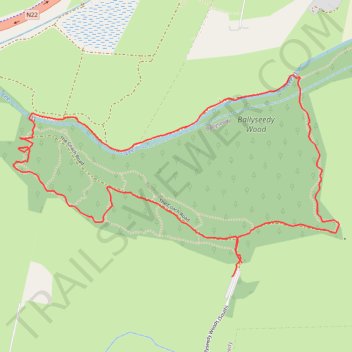
Ballyseedy Wood loop walk
- Distance: 1.8 mi
- Elevation gain: 72 ft
- Maximum elevation: 75 ft
- Elevation loss: 72 ft
- Minimum elevation: 30 ft
- Moving time: 40 m 57 s
- Moving speed: 2.7 mph
- Maximum speed: 6.5 mph
- Total time: 44 m 24 s
- Global speed: 2.5 mph
Interactive trail map
Trail profile
- Distance: 1.8 mi
- Elevation gain: 72 ft
- Maximum elevation: 75 ft
- Elevation loss: 72 ft
- Minimum elevation: 30 ft
- Moving time: 40 m 57 s
- Moving speed: 2.7 mph
- Maximum speed: 6.5 mph
- Total time: 44 m 24 s
- Global speed: 2.5 mph
About this trail
Name: Ballyseedy Wood loop walk trail, distance, elevation, map, profile, GPS track
Coordinates: 52.25154 -9.66733 52.25646 -9.65435