Thank you for supporting this site ❤️
Make a donation
Make a donation
Gear up for your next adventure:
As an Amazon Associate, this site earns from qualifying purchases at no extra cost to you.
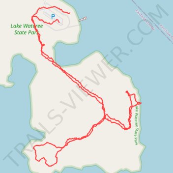
Lake Wateree State Park
- Distance: 2.5 mi
- Elevation gain: 33 ft
- Maximum elevation: 249 ft
- Elevation loss: 39 ft
- Minimum elevation: 226 ft
- Moving time: 1 h 1 m
- Moving speed: 2.5 mph
- Maximum speed: 5.9 mph
- Total time: 1 h 2 m
- Global speed: 2.4 mph
Interactive trail map
Thank you for supporting this site ❤️
Make a donation
Make a donation
Gear up for your next adventure:
As an Amazon Associate, this site earns from qualifying purchases at no extra cost to you.
Trail profile
- Distance: 2.5 mi
- Elevation gain: 33 ft
- Maximum elevation: 249 ft
- Elevation loss: 39 ft
- Minimum elevation: 226 ft
- Moving time: 1 h 1 m
- Moving speed: 2.5 mph
- Maximum speed: 5.9 mph
- Total time: 1 h 2 m
- Global speed: 2.4 mph
Thank you for supporting this site ❤️
Make a donation
Make a donation
Gear up for your next adventure:
As an Amazon Associate, this site earns from qualifying purchases at no extra cost to you.
About this trail
Name: Lake Wateree State Park trail, distance, elevation, map, profile, GPS track
Start: State Park Road, Fairfield County, South Carolina, 29180, United States (34.43299 -80.85948)
Coordinates: 34.42602 -80.86109 34.43376 -80.85465
Topography: Fairfield County topographic map, elevation, terrain
Thank you for supporting this site ❤️
Make a donation
Make a donation
Gear up for your next adventure:
As an Amazon Associate, this site earns from qualifying purchases at no extra cost to you.