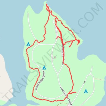
Loop walk in Eisenhower State Park
- Distance: 1.8 mi
- Elevation gain: 236 ft
- Maximum elevation: 712 ft
- Elevation loss: 236 ft
- Minimum elevation: 623 ft
- Moving time: 42 m 49 s
- Moving speed: 2.5 mph
- Maximum speed: 3.9 mph
- Total time: 47 m 27 s
- Global speed: 2.3 mph
Interactive trail map
Trail profile
- Distance: 1.8 mi
- Elevation gain: 236 ft
- Maximum elevation: 712 ft
- Elevation loss: 236 ft
- Minimum elevation: 623 ft
- Moving time: 42 m 49 s
- Moving speed: 2.5 mph
- Maximum speed: 3.9 mph
- Total time: 47 m 27 s
- Global speed: 2.3 mph
About this trail
Name: Loop walk in Eisenhower State Park trail, distance, elevation, map, profile, GPS track
Start: Fossil Ridge Drive, Grayson County, Texas, United States (33.82812 -96.61855)
End: Fossil Ridge Drive, Grayson County, Texas, United States (33.82788 -96.61817)
Coordinates: 33.82414 -96.62086 33.83030 -96.61684
Topography: Grayson County topographic map, elevation, terrain