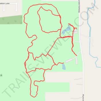
Plum Creek Park
- Distance: 3.1 mi
- Elevation gain: 213 ft
- Maximum elevation: 1,161 ft
- Elevation loss: 164 ft
- Minimum elevation: 1,066 ft
- Moving time: 1 h 1 m
- Moving speed: 3.0 mph
- Maximum speed: 5.1 mph
- Total time: 1 h 2 m
- Global speed: 3.0 mph
Interactive trail map
Trail profile
- Distance: 3.1 mi
- Elevation gain: 213 ft
- Maximum elevation: 1,161 ft
- Elevation loss: 164 ft
- Minimum elevation: 1,066 ft
- Moving time: 1 h 1 m
- Moving speed: 3.0 mph
- Maximum speed: 5.1 mph
- Total time: 1 h 2 m
- Global speed: 3.0 mph
About this trail
Name: Plum Creek Park trail, distance, elevation, map, profile, GPS track
Coordinates: 41.20494 -81.81324 41.21239 -81.80761
Topography: Medina County topographic map, elevation, terrain
Other hiking, mountain biking, running and outdoor activity trails
Click on a trail to view its statistics, map and profile.
Plum Creek Greenway
United States > Ohio > Medina County > Brunswick
Distance: 4.2 mi • Elevation gain: 184 ft • Maximum elevation: 1,125 ft