Thank you for supporting this site ❤️
Make a donation
Make a donation
Gear up for your next adventure:
As an Amazon Associate, this site earns from qualifying purchases at no extra cost to you.
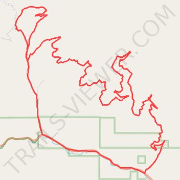
Bear Creek / Grave Creek Loop
- Distance: 32.3 mi
- Elevation gain: 4,970 ft
- Maximum elevation: 6,191 ft
- Elevation loss: 4,990 ft
- Minimum elevation: 3,648 ft
- Moving time: 3 h 42 m
- Moving speed: 8.7 mph
- Maximum speed: 28.7 mph
- Total time: 4 h 14 m
- Global speed: 7.6 mph
Interactive trail map
Thank you for supporting this site ❤️
Make a donation
Make a donation
Gear up for your next adventure:
As an Amazon Associate, this site earns from qualifying purchases at no extra cost to you.
Trail profile
- Distance: 32.3 mi
- Elevation gain: 4,970 ft
- Maximum elevation: 6,191 ft
- Elevation loss: 4,990 ft
- Minimum elevation: 3,648 ft
- Moving time: 3 h 42 m
- Moving speed: 8.7 mph
- Maximum speed: 28.7 mph
- Total time: 4 h 14 m
- Global speed: 7.6 mph
Thank you for supporting this site ❤️
Make a donation
Make a donation
Gear up for your next adventure:
As an Amazon Associate, this site earns from qualifying purchases at no extra cost to you.
About this trail
Name: Bear Creek / Grave Creek Loop trail, distance, elevation, map, profile, GPS track
Start: Bear Creek Road, Missoula County, Montana, United States (46.76839 -114.32376)
End: Bear Creek Road, Missoula County, Montana, United States (46.76825 -114.32368)
Coordinates: 46.76430 -114.41816 46.84281 -114.31521
Topography: Missoula County topographic map, elevation, terrain
Thank you for supporting this site ❤️
Make a donation
Make a donation
Gear up for your next adventure:
As an Amazon Associate, this site earns from qualifying purchases at no extra cost to you.