Make a donation
Gear up for your next adventure:
As an Amazon Associate, this site earns from qualifying purchases at no extra cost to you.
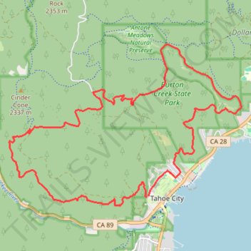
Tahoe Rim Trail to Burtron Creek trails
#TRT
- Distance: 13.3 mi
- Elevation gain: 1,995 ft
- Maximum elevation: 7,428 ft
- Elevation loss: 2,014 ft
- Minimum elevation: 6,280 ft
- Moving time: 3 h 8 m
- Moving speed: 4.2 mph
- Maximum speed: 10.8 mph
- Total time: 3 h 12 m
- Global speed: 4.1 mph
Interactive trail map
Make a donation
Gear up for your next adventure:
As an Amazon Associate, this site earns from qualifying purchases at no extra cost to you.
Trail profile
- Distance: 13.3 mi
- Elevation gain: 1,995 ft
- Maximum elevation: 7,428 ft
- Elevation loss: 2,014 ft
- Minimum elevation: 6,280 ft
- Moving time: 3 h 8 m
- Moving speed: 4.2 mph
- Maximum speed: 10.8 mph
- Total time: 3 h 12 m
- Global speed: 4.1 mph
Make a donation
Gear up for your next adventure:
As an Amazon Associate, this site earns from qualifying purchases at no extra cost to you.
About this trail
Name: Tahoe Rim Trail to Burtron Creek trails trail, distance, elevation, map, profile, GPS track
Coordinates: 39.16724 -120.18652 39.20142 -120.12324
Topography: Placer County topographic map, elevation, terrain
Make a donation
Gear up for your next adventure:
As an Amazon Associate, this site earns from qualifying purchases at no extra cost to you.
Other hiking, mountain biking, running and outdoor activity trails
Click on a trail to view its statistics, map and profile.
Thunder Mountain Trail, Five Lakes Trail, Bear Creek Trail and Western States Trail Loop in Tahoe National Forest
United States > California > Placer County > Olympic Valley
Distance: 16.7 mi • Elevation gain: 3,865 ft • Maximum elevation: 7,726 ft