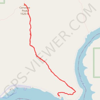
Cervidae Peak Trail in Idaho
The Cervidae Peak Trail is a steep but rewarding hike. The path ascends through open, sagebrush-covered hills, with the effort paying off in sweeping views of the Lucky Peak and Arrowrock reservoirs, as well as the Boise foothills. While challenging due to its steep elevation gain, the summit offers a serene reward with vistas stretching toward distant mountains and valleys. This hike is a favorite for those seeking a quick yet intense adventure close to the city. #Hiking #Mountain #Nature
- Distance: 4.7 mi
- Elevation gain: 1,942 ft
- Maximum elevation: 4,954 ft
- Elevation loss: 1,939 ft
- Minimum elevation: 3,094 ft
- Moving time: 1 h 58 m
- Moving speed: 2.4 mph
- Maximum speed: 4.2 mph
- Total time: 2 h 20 m
- Global speed: 2.0 mph
Interactive trail map
Trail profile
- Distance: 4.7 mi
- Elevation gain: 1,942 ft
- Maximum elevation: 4,954 ft
- Elevation loss: 1,939 ft
- Minimum elevation: 3,094 ft
- Moving time: 1 h 58 m
- Moving speed: 2.4 mph
- Maximum speed: 4.2 mph
- Total time: 2 h 20 m
- Global speed: 2.0 mph
About this trail
Name: Cervidae Peak Trail in Idaho trail, distance, elevation, map, profile, GPS track
Start: Arrow Rock Road, Boise County, Idaho, United States (43.59192 -115.96239)
End: Arrow Rock Road, Boise County, Idaho, United States (43.59195 -115.96241)
Coordinates: 43.59192 -115.97419 43.61426 -115.95709
Topography: Boise County topographic map, elevation, terrain