
Chauncey Peak Loop Trail in Giuffrida Park
The Chauncey Peak Loop Trail offers hikers a blend of rugged terrain and stunning views. As you ascend, you’ll encounter rocky ledges that provide panoramic vistas overlooking Crescent Lake and the distant skyline of Hartford, along with the impressive Hanging Hills and Sleeping Giant mountains. The diverse landscape, filled with traprock formations and dense woodlands, makes this trail a rewarding experience for nature enthusiasts and photographers alike. #Hiking #Loop #Forest #Nature #Lake
- Distance: 2.3 mi
- Elevation gain: 407 ft
- Maximum elevation: 630 ft
- Elevation loss: 423 ft
- Minimum elevation: 292 ft
- Moving time: 1 h 24 m
- Moving speed: 1.7 mph
- Maximum speed: 4.7 mph
- Total time: 1 h 45 m
- Global speed: 1.3 mph
Interactive trail map
Trail profile
- Distance: 2.3 mi
- Elevation gain: 407 ft
- Maximum elevation: 630 ft
- Elevation loss: 423 ft
- Minimum elevation: 292 ft
- Moving time: 1 h 24 m
- Moving speed: 1.7 mph
- Maximum speed: 4.7 mph
- Total time: 1 h 45 m
- Global speed: 1.3 mph
About this trail
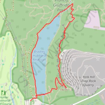
Name: Chauncey Peak Loop Trail in Giuffrida Park trail, distance, elevation, map, profile, GPS track
Coordinates: 41.55600 -72.76464 41.56721 -72.75783
Topography: Meriden topographic map, elevation, terrain
Other hiking, mountain biking, running and outdoor activity trails
Click on a trail to view its statistics, map and profile.
Giuffrida Park Loop via Chauncey Peak
United States > Connecticut > South Central Connecticut Planning Region > Meriden
The Giuffrida Park Loop is a moderate hike that rewards visitors with varied scenery, from the Bradley Hubbard Reservoir — now known as Crescent Lake — to sweeping views atop Chauncey Peak. The trail ascends through a wooded path and offers ridge views of Crescent Lake, with occasional glimpses of…
Distance: 4.2 mi • Elevation gain: 758 ft • Maximum elevation: 673 ft