Iron Mountain
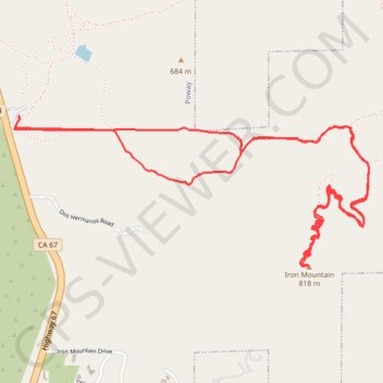
From Poway Road Park and Ride, the route follows Iron Mountain Peak Trail through a short shaded start, then across open chaparral, granite outcrops, rolling foothills, and increasingly exposed slopes toward the summit of Iron Mountain.
After passing the Iron Mountain Junction and the slopes around Little Iron Mountain, the trail climbs a winding sequence of switchbacks to the summit area, where wide views open over Poway, Ramona Valley, Woodson Mountain, the inland San Diego hills, and the distant coast.
The return first retraces the main summit trail, then makes a gentler scenic detour by way of the Ellie Lane and Wild Horse Trail area before rejoining Iron Mountain Peak Trail and heading back to Poway Road Park and Ride.
#Hiking #Mountain #Forest #Nature #Summit #Panorama
- Distance: 5.2 mi
- Elevation gain: 1,125 ft
- Maximum elevation: 2,638 ft
- Elevation loss: 1,125 ft
- Minimum elevation: 1,601 ft
Interactive trail map
Trail profile
- Distance: 5.2 mi
- Elevation gain: 1,125 ft
- Maximum elevation: 2,638 ft
- Elevation loss: 1,125 ft
- Minimum elevation: 1,601 ft
About this trail
Name: Iron Mountain trail, distance, elevation, map, profile, GPS track
Coordinates: 32.97081 -116.97270 32.97817 -116.95193
Topography: Poway topographic map, elevation, terrain
Other hiking, mountain biking, running and outdoor activity trails
Click on a trail to view its statistics, map and profile.
Iron Mountain Peak Trail
United States > California > San Diego County > Poway
Iron Mountain Peak Trail offers a rewarding hike with a mix of scenic landscapes and challenging ascents. The route is particularly notable for its panoramic views, including sweeping vistas of surrounding mountains like Cuyamaca Peak and El Cajon Mountain, as well as distant sights of San Diego and the ocean.…
Distance: 5.6 mi • Elevation gain: 1,184 ft • Maximum elevation: 2,635 ft