San Gorgonio Mountain (Vivian Creek Trail)
Hike to the San Gorgonio Mountain by the Vivian Creek Trail in the San Gorgonio Wilderness. #Hiking #Mountain #Nature #Forest #Wilderness
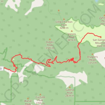
- Distance: 8.9 mi
- Elevation gain: 5,479 ft
- Maximum elevation: 11,490 ft
- Elevation loss: 95 ft
- Minimum elevation: 6,106 ft
Interactive trail map
Trail profile
- Distance: 8.9 mi
- Elevation gain: 5,479 ft
- Maximum elevation: 11,490 ft
- Elevation loss: 95 ft
- Minimum elevation: 6,106 ft
About this trail
Name: San Gorgonio Mountain (Vivian Creek Trail) trail, distance, elevation, map, profile, GPS track
Start: Vivian Trailhead, San Bernardino County, California, 92339, United States (34.08172 -116.89102)
End: San Gorgonio Mountain Trail, San Bernardino County, California, United States (34.09927 -116.82486)
Coordinates: 34.07951 -116.89102 34.10144 -116.82483
Topography: San Bernardino County topographic map, elevation, terrain
Other hiking, mountain biking, running and outdoor activity trails
Click on a trail to view its statistics, map and profile.
San Gorgonio Mountain via Vivian Creek Trail in San Gorgonio Wilderness
United States > California > San Bernardino County
The Vivian Creek Trail to San Gorgonio Mountain offers hikers a challenging ascent through diverse terrains, including shaded forests, alpine meadows, and rocky ridgelines. Along the route, one can observe a variety of plant life, from dense woodlands at lower elevations to sparse vegetation near the summit.…
Distance: 18.0 mi • Elevation gain: 5,574 ft • Maximum elevation: 11,490 ft
Dobbs Cabin
United States > California > San Bernardino County > Forest Falls
Hike to Dobbs Cabin Camp by the Momyer Creek Trail, the Fals Creek Trail and the Dobbs Cabin Spur in the San Gorgonio Wilderness, the Sand to Snow National Monument and the San Bernardino National Forest. #Hiking #Mountain #Forest #Nature #Wilderness
Distance: 5.6 mi • Elevation gain: 2,792 ft • Maximum elevation: 7,513 ft
San Gorgonio Mountain (South Fork Trail)
United States > California > San Bernardino County
Hike to San Gorgonio Mountain via South Fork Trail, Poopout Hill, Dollar Lake Saddle, San Bernardino Peak Trail and San Gorgonio Mountain Trail in the Sand to Snow National Monument and the San Gorgonio Wilderness. #Hiking #Mountain #Nature #Forest #Wilderness
Distance: 9.5 mi • Elevation gain: 4,675 ft • Maximum elevation: 11,490 ft