Import a GPX file

Hot Spring Canyon Falls

Hike to Hot Spring Canyon Falls in the Cleveland National Forest. #Hiking #Falls #Canyon #Nature #Forest #River

  • Distance: 1.5 mi
  • Elevation gain: 82 ft
  • Maximum elevation: 3,323 ft
  • Elevation loss: 476 ft
  • Minimum elevation: 2,917 ft

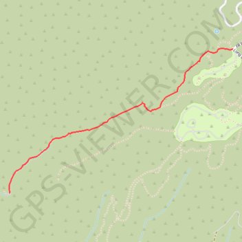
Interactive trail map

Trail profile

  • Distance: 1.5 mi
  • Elevation gain: 82 ft
  • Maximum elevation: 3,323 ft
  • Elevation loss: 476 ft
  • Minimum elevation: 2,917 ft

About this trail

Name: Hot Spring Canyon Falls trail, distance, elevation, map, profile, GPS track

Start: Falcon Group Campsite, Long Canyon Road, Orange County, California, 90000, United States (33.65775 -117.45092)

End: Orange County, California, United States (33.64735 -117.47030)

Coordinates: 33.64735 -117.47030 33.65778 -117.45092

Topography: Orange County topographic map, elevation, terrain

Gear up for your next adventure:

🪑Portable Camp Table - Compact table for campsite meals
🦶Carbon Trekking Poles - Reduce knee impact on steep descents with ultra-light poles
🧭GPS Watch Accessories - Bands and chargers for GPS watches
🔪Outdoor Multitools - Essential survival tools for gear repair and field use
🎒Day Hiking Backpack - Lightweight backpack perfect for day trips and outdoor adventures

As an Amazon Associate, this site earns from qualifying purchases at no extra cost to you.