Make a donation
Gear up for your next adventure:
As an Amazon Associate, this site earns from qualifying purchases at no extra cost to you.
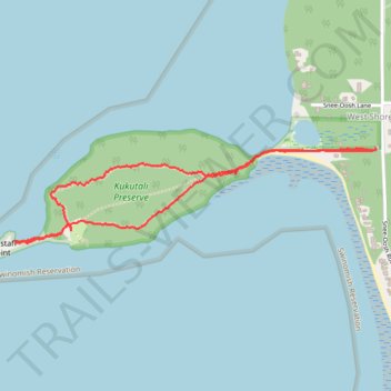
Kukutali Preseve Loop
- Distance: 2.2 mi
- Elevation gain: 433 ft
- Maximum elevation: 207 ft
- Elevation loss: 427 ft
- Minimum elevation: -3 ft
- Moving time: 1 h 15 m
- Moving speed: 1.8 mph
- Maximum speed: 3.2 mph
- Total time: 1 h 52 m
- Global speed: 1.2 mph
Interactive trail map
Make a donation
Gear up for your next adventure:
As an Amazon Associate, this site earns from qualifying purchases at no extra cost to you.
Trail profile
- Distance: 2.2 mi
- Elevation gain: 433 ft
- Maximum elevation: 207 ft
- Elevation loss: 427 ft
- Minimum elevation: -3 ft
- Moving time: 1 h 15 m
- Moving speed: 1.8 mph
- Maximum speed: 3.2 mph
- Total time: 1 h 52 m
- Global speed: 1.2 mph
Make a donation
Gear up for your next adventure:
As an Amazon Associate, this site earns from qualifying purchases at no extra cost to you.
About this trail
Name: Kukutali Preseve Loop trail, distance, elevation, map, profile, GPS track
Start: Kiket Island Road, West Shore, Skagit County, Washington, 98257, United States (48.42092 -122.55367)
End: Kiket Island Road, West Shore, Skagit County, Washington, 98257, United States (48.42099 -122.55349)
Coordinates: 48.41752 -122.57324 48.42099 -122.55344
Topography: Skagit County topographic map, elevation, terrain
Make a donation
Gear up for your next adventure:
As an Amazon Associate, this site earns from qualifying purchases at no extra cost to you.