Make a donation
Gear up for your next adventure:
As an Amazon Associate, this site earns from qualifying purchases at no extra cost to you.
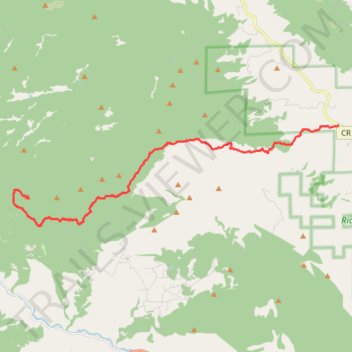
Trails and roads to the Storm Mountain summit
- Distance: 11.4 mi
- Elevation gain: 4,626 ft
- Maximum elevation: 9,849 ft
- Elevation loss: 331 ft
- Minimum elevation: 5,545 ft
Interactive trail map
Make a donation
Gear up for your next adventure:
As an Amazon Associate, this site earns from qualifying purchases at no extra cost to you.
Trail profile
- Distance: 11.4 mi
- Elevation gain: 4,626 ft
- Maximum elevation: 9,849 ft
- Elevation loss: 331 ft
- Minimum elevation: 5,545 ft
Make a donation
Gear up for your next adventure:
As an Amazon Associate, this site earns from qualifying purchases at no extra cost to you.
About this trail
Name: Trails and roads to the Storm Mountain summit trail, distance, elevation, map, profile, GPS track
Start: 12134, Buckhorn Road, Larimer County, Colorado, 80538, United States (40.50972 -105.24650)
End: Foggy Park Road, Larimer County, Colorado, 80515, United States (40.48512 -105.38591)
Coordinates: 40.47547 -105.39213 40.50972 -105.24650
Topography: Larimer County topographic map, elevation, terrain
Make a donation
Gear up for your next adventure:
As an Amazon Associate, this site earns from qualifying purchases at no extra cost to you.