Mickleton Hills
- Distance: 13.7 mi
- Elevation gain: 1,535 ft
- Maximum elevation: 860 ft
- Elevation loss: 1,535 ft
- Minimum elevation: 233 ft
- Moving time: 2 h 21 m
- Moving speed: 5.8 mph
- Maximum speed: 10.3 mph
- Total time: 2 h 22 m
- Global speed: 5.8 mph
Interactive trail map
Trail profile
- Distance: 13.7 mi
- Elevation gain: 1,535 ft
- Maximum elevation: 860 ft
- Elevation loss: 1,535 ft
- Minimum elevation: 233 ft
- Moving time: 2 h 21 m
- Moving speed: 5.8 mph
- Maximum speed: 10.3 mph
- Total time: 2 h 22 m
- Global speed: 5.8 mph
About this trail
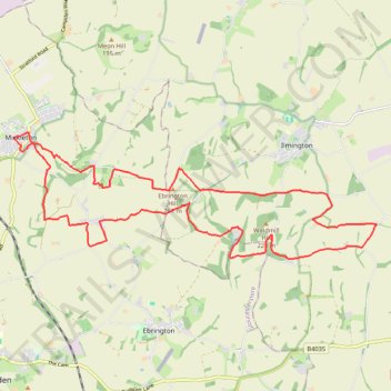
Name: Mickleton Hills trail, distance, elevation, map, profile, GPS track
Coordinates: 52.06992 -1.77037 52.09122 -1.67156
Other hiking, mountain biking, running and outdoor activity trails
Click on a trail to view its statistics, map and profile.
Mickleton Trailrun
United Kingdom > England > Gloucestershire > Cotswold District > Mickleton
Distance: 7.4 mi • Elevation gain: 623 ft • Maximum elevation: 653 ft