Make a donation
Gear up for your next adventure:
As an Amazon Associate, this site earns from qualifying purchases at no extra cost to you.
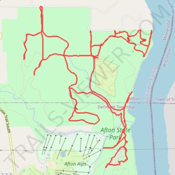
Afton State Park Trails
- Distance: 12.6 mi
- Elevation gain: 1,273 ft
- Maximum elevation: 1,007 ft
- Elevation loss: 1,273 ft
- Minimum elevation: 689 ft
- Moving time: 3 h 47 m
- Moving speed: 3.3 mph
- Maximum speed: 5.1 mph
- Total time: 4 h 2 m
- Global speed: 3.1 mph
Interactive trail map
Make a donation
Gear up for your next adventure:
As an Amazon Associate, this site earns from qualifying purchases at no extra cost to you.
Trail profile
- Distance: 12.6 mi
- Elevation gain: 1,273 ft
- Maximum elevation: 1,007 ft
- Elevation loss: 1,273 ft
- Minimum elevation: 689 ft
- Moving time: 3 h 47 m
- Moving speed: 3.3 mph
- Maximum speed: 5.1 mph
- Total time: 4 h 2 m
- Global speed: 3.1 mph
Make a donation
Gear up for your next adventure:
As an Amazon Associate, this site earns from qualifying purchases at no extra cost to you.
About this trail
Name: Afton State Park Trails trail, distance, elevation, map, profile, GPS track
Coordinates: 44.85238 -92.79567 44.87639 -92.76884
Topography: Denmark Township topographic map, elevation, terrain
Make a donation
Gear up for your next adventure:
As an Amazon Associate, this site earns from qualifying purchases at no extra cost to you.
Other hiking, mountain biking, running and outdoor activity trails
Click on a trail to view its statistics, map and profile.
North River Loop Trail in Afton State Park
United States > Minnesota > Washington County
The North River Loop Trail offers a dynamic hiking experience with diverse landscapes, including river views, lush forests, and open meadows. Along the route, hikers can spot a variety of wildlife, including bald eagles, and enjoy picturesque vistas over the St. Croix River. With moderate elevation changes and…
Distance: 4.0 mi • Elevation gain: 528 ft • Maximum elevation: 988 ft