2016-08-22 20:01:30
- Distance: 4.4 mi
- Elevation gain: 167 ft
- Maximum elevation: 2,513 ft
- Elevation loss: 167 ft
- Minimum elevation: 2,356 ft
- Moving time: 1 h 4 m
- Moving speed: 4.1 mph
- Maximum speed: 5.5 mph
- Total time: 1 h 21 m
- Global speed: 3.2 mph
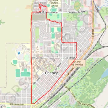
Interactive trail map
Trail profile
- Distance: 4.4 mi
- Elevation gain: 167 ft
- Maximum elevation: 2,513 ft
- Elevation loss: 167 ft
- Minimum elevation: 2,356 ft
- Moving time: 1 h 4 m
- Moving speed: 4.1 mph
- Maximum speed: 5.5 mph
- Total time: 1 h 21 m
- Global speed: 3.2 mph
About this trail
Name: 2016-08-22 20:01:30 trail, distance, elevation, map, profile, GPS track
Start: 1090, West Betz Road, Cheney, Spokane County, Washington, 99004, United States (47.50467 -117.58317)
End: 1090, West Betz Road, Cheney, Spokane County, Washington, 99004, United States (47.50461 -117.58315)
Coordinates: 47.48179 -117.58649 47.50553 -117.57029
Topography: Spokane County topographic map, elevation, terrain