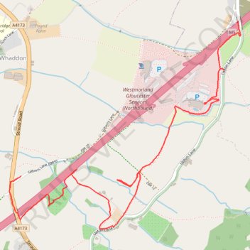
Public footpaths along M5 in Brookthorpe
- Distance: 2.8 mi
- Elevation gain: 79 ft
- Maximum elevation: 210 ft
- Elevation loss: 148 ft
- Minimum elevation: 125 ft
- Moving time: 1 h 14 m
- Moving speed: 2.3 mph
- Maximum speed: 4.5 mph
- Total time: 1 h 39 m
- Global speed: 1.7 mph
Interactive trail map
Trail profile
- Distance: 2.8 mi
- Elevation gain: 79 ft
- Maximum elevation: 210 ft
- Elevation loss: 148 ft
- Minimum elevation: 125 ft
- Moving time: 1 h 14 m
- Moving speed: 2.3 mph
- Maximum speed: 4.5 mph
- Total time: 1 h 39 m
- Global speed: 1.7 mph
About this trail
Name: Public footpaths along M5 in Brookthorpe trail, distance, elevation, map, profile, GPS track
Coordinates: 51.81030 -2.24238 51.82324 -2.21917
Other hiking, mountain biking, running and outdoor activity trails
Click on a trail to view its statistics, map and profile.
Dean2023-311
United Kingdom > England > Oxfordshire > Oxford
Distance: 192.8 mi • Elevation gain: 11,043 ft • Maximum elevation: 951 ft