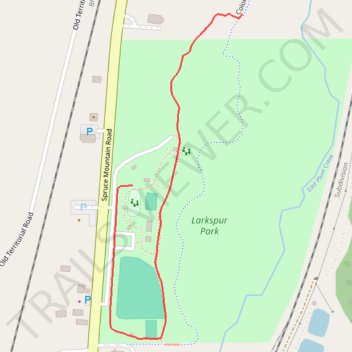
Larkspur Park
- Distance: 0.5 mi
- Elevation gain: 43 ft
- Maximum elevation: 6,690 ft
- Elevation loss: 20 ft
- Minimum elevation: 6,650 ft
- Moving time: 11 m 5 s
- Moving speed: 3.0 mph
- Maximum speed: 3.7 mph
- Total time: 11 m 5 s
- Global speed: 3.0 mph
Interactive trail map
Trail profile
- Distance: 0.5 mi
- Elevation gain: 43 ft
- Maximum elevation: 6,690 ft
- Elevation loss: 20 ft
- Minimum elevation: 6,650 ft
- Moving time: 11 m 5 s
- Moving speed: 3.0 mph
- Maximum speed: 3.7 mph
- Total time: 11 m 5 s
- Global speed: 3.0 mph
About this trail
Name: Larkspur Park trail, distance, elevation, map, profile, GPS track
End: Spruce Mountain Road, Larkspur, Douglas County, Colorado, 80118, United States (39.23243 -104.88351)
Coordinates: 39.23036 -104.88390 39.23475 -104.88160
Topography: Douglas County topographic map, elevation, terrain