Thank you for supporting this site ❤️
Make a donation
Make a donation
Gear up for your next adventure:
As an Amazon Associate, this site earns from qualifying purchases at no extra cost to you.
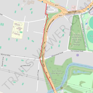
Lower Plenty, Fitzsimons Lane Linear Reserve, cycleway / path
- Distance: 1.3 mi
- Elevation gain: 203 ft
- Maximum elevation: 210 ft
- Elevation loss: 210 ft
- Minimum elevation: 66 ft
- Moving time: 29 m 45 s
- Moving speed: 2.7 mph
- Maximum speed: 3.6 mph
- Total time: 31 m 14 s
- Global speed: 2.5 mph
Interactive trail map
Thank you for supporting this site ❤️
Make a donation
Make a donation
Gear up for your next adventure:
As an Amazon Associate, this site earns from qualifying purchases at no extra cost to you.
Trail profile
- Distance: 1.3 mi
- Elevation gain: 203 ft
- Maximum elevation: 210 ft
- Elevation loss: 210 ft
- Minimum elevation: 66 ft
- Moving time: 29 m 45 s
- Moving speed: 2.7 mph
- Maximum speed: 3.6 mph
- Total time: 31 m 14 s
- Global speed: 2.5 mph
Thank you for supporting this site ❤️
Make a donation
Make a donation
Gear up for your next adventure:
As an Amazon Associate, this site earns from qualifying purchases at no extra cost to you.
About this trail
Name: Lower Plenty, Fitzsimons Lane Linear Reserve, cycleway / path trail, distance, elevation, map, profile, GPS track
Coordinates: -37.74079 145.13388 -37.73221 145.13559
Thank you for supporting this site ❤️
Make a donation
Make a donation
Gear up for your next adventure:
As an Amazon Associate, this site earns from qualifying purchases at no extra cost to you.
Other hiking, mountain biking, running and outdoor activity trails
Click on a trail to view its statistics, map and profile.
Tallarook - Eildon - Hurstbridge
Australia > Victoria > Tallarook
#Bike
Distance: 173.2 mi • Elevation gain: 16,066 ft • Maximum elevation: 2,848 ft