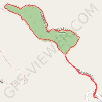
Lady Bird Grove Loop Trail
- Distance: 1.6 mi
- Elevation gain: 161 ft
- Maximum elevation: 1,378 ft
- Elevation loss: 167 ft
- Minimum elevation: 1,280 ft
- Moving time: 45 m 2 s
- Moving speed: 2.1 mph
- Maximum speed: 5.5 mph
- Total time: 53 m 11 s
- Global speed: 1.8 mph
Interactive trail map
Trail profile
- Distance: 1.6 mi
- Elevation gain: 161 ft
- Maximum elevation: 1,378 ft
- Elevation loss: 167 ft
- Minimum elevation: 1,280 ft
- Moving time: 45 m 2 s
- Moving speed: 2.1 mph
- Maximum speed: 5.5 mph
- Total time: 53 m 11 s
- Global speed: 1.8 mph
About this trail
Name: Lady Bird Grove Loop Trail trail, distance, elevation, map, profile, GPS track
Start: Bald Hills Road, Humboldt County, California, 85555, United States (41.30345 -124.01819)
End: Lady Bird Grove Trail, Humboldt County, California, 85555, United States (41.30357 -124.01843)
Coordinates: 41.30345 -124.02599 41.30936 -124.01819
Topography: Humboldt County topographic map, elevation, terrain