Make a donation
Gear up for your next adventure:
As an Amazon Associate, this site earns from qualifying purchases at no extra cost to you.
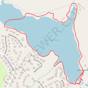
Afternoon hike at Lake Wilson Loop Trail
Wilson Lake
- Distance: 2.5 mi
- Elevation gain: 118 ft
- Maximum elevation: 144 ft
- Elevation loss: 115 ft
- Minimum elevation: 112 ft
- Moving time: 44 m 40 s
- Moving speed: 3.3 mph
- Maximum speed: 11.1 mph
- Total time: 44 m 40 s
- Global speed: 3.3 mph
Interactive trail map
Make a donation
Gear up for your next adventure:
As an Amazon Associate, this site earns from qualifying purchases at no extra cost to you.
Trail profile
- Distance: 2.5 mi
- Elevation gain: 118 ft
- Maximum elevation: 144 ft
- Elevation loss: 115 ft
- Minimum elevation: 112 ft
- Moving time: 44 m 40 s
- Moving speed: 3.3 mph
- Maximum speed: 11.1 mph
- Total time: 44 m 40 s
- Global speed: 3.3 mph
Make a donation
Gear up for your next adventure:
As an Amazon Associate, this site earns from qualifying purchases at no extra cost to you.
About this trail
Name: Afternoon hike at Lake Wilson Loop Trail trail, distance, elevation, map, profile, GPS track
Start: Lake Wilson Loop, Wilson, Wilson County, North Carolina, United States (35.78910 -77.92008)
End: Lake Wilson Loop, Wilson, Wilson County, North Carolina, United States (35.78901 -77.91993)
Coordinates: 35.78852 -77.92936 35.79657 -77.91970
Topography: Wilson topographic map, elevation, terrain
Make a donation
Gear up for your next adventure:
As an Amazon Associate, this site earns from qualifying purchases at no extra cost to you.
Other hiking, mountain biking, running and outdoor activity trails
Click on a trail to view its statistics, map and profile.
Lake Wilson Loop Trail
United States > North Carolina > Wilson County > Wilson
Distance: 2.3 mi • Elevation gain: 125 ft • Maximum elevation: 154 ft