Thank you for supporting this site ❤️
Make a donation
Make a donation
Gear up for your next adventure:
As an Amazon Associate, this site earns from qualifying purchases at no extra cost to you.
Port Joli Head Loop
Interactive trail map
Thank you for supporting this site ❤️
Make a donation
Make a donation
Gear up for your next adventure:
As an Amazon Associate, this site earns from qualifying purchases at no extra cost to you.
Trail profile
- Distance: 5.0 mi
- Elevation gain: 184 ft
- Maximum elevation: 108 ft
- Elevation loss: 184 ft
- Minimum elevation: 0 ft
- Moving time: 1 h 39 m
- Moving speed: 3.1 mph
- Maximum speed: 6.0 mph
- Total time: 1 h 47 m
- Global speed: 2.8 mph
Thank you for supporting this site ❤️
Make a donation
Make a donation
Gear up for your next adventure:
As an Amazon Associate, this site earns from qualifying purchases at no extra cost to you.
About this trail
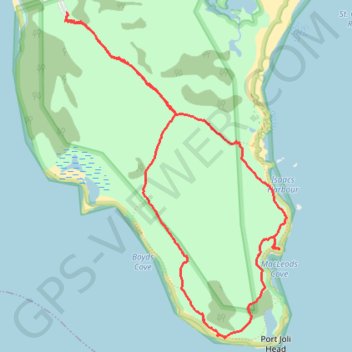
Name: Port Joli Head Loop trail, distance, elevation, map, profile, GPS track
Coordinates: 43.81376 -64.85630 43.83792 -64.83352
Thank you for supporting this site ❤️
Make a donation
Make a donation
Gear up for your next adventure:
As an Amazon Associate, this site earns from qualifying purchases at no extra cost to you.