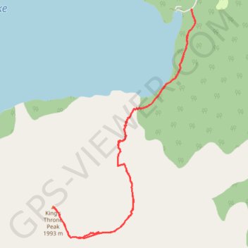
Kings Throne Summit Hike in Kluane Park Yukon Canada
- Distance: 8.3 mi
- Elevation gain: 4,304 ft
- Maximum elevation: 6,575 ft
- Elevation loss: 4,304 ft
- Minimum elevation: 2,428 ft
- Moving time: 5 h 19 m
- Moving speed: 1.6 mph
- Maximum speed: 4.2 mph
- Total time: 8 h 13 m
- Global speed: 1.0 mph
Interactive trail map
Trail profile
- Distance: 8.3 mi
- Elevation gain: 4,304 ft
- Maximum elevation: 6,575 ft
- Elevation loss: 4,304 ft
- Minimum elevation: 2,428 ft
- Moving time: 5 h 19 m
- Moving speed: 1.6 mph
- Maximum speed: 4.2 mph
- Total time: 8 h 13 m
- Global speed: 1.0 mph
About this trail
Name: Kings Throne Summit Hike in Kluane Park Yukon Canada trail, distance, elevation, map, profile, GPS track
Start: King's Throne Trail, Yukon, Canada (60.57628 -137.21781)
End: King's Throne Trail, Yukon, Canada (60.57631 -137.21811)
Coordinates: 60.54212 -137.26009 60.57638 -137.21680