Make a donation
Gear up for your next adventure:
As an Amazon Associate, this site earns from qualifying purchases at no extra cost to you.
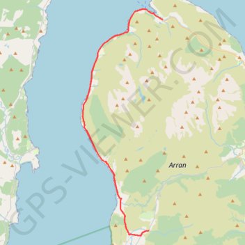
Bridgend Campsite to Lochranza and back
Arran, Scotland
- Distance: 36.8 mi
- Elevation gain: 1,837 ft
- Maximum elevation: 194 ft
- Elevation loss: 1,837 ft
- Minimum elevation: -7 ft
- Moving time: 2 h 50 m
- Moving speed: 13.0 mph
- Maximum speed: 26.0 mph
- Total time: 7 h 40 m
- Global speed: 4.8 mph
Interactive trail map
Make a donation
Gear up for your next adventure:
As an Amazon Associate, this site earns from qualifying purchases at no extra cost to you.
Trail profile
- Distance: 36.8 mi
- Elevation gain: 1,837 ft
- Maximum elevation: 194 ft
- Elevation loss: 1,837 ft
- Minimum elevation: -7 ft
- Moving time: 2 h 50 m
- Moving speed: 13.0 mph
- Maximum speed: 26.0 mph
- Total time: 7 h 40 m
- Global speed: 4.8 mph
Make a donation
Gear up for your next adventure:
As an Amazon Associate, this site earns from qualifying purchases at no extra cost to you.
About this trail
Name: Bridgend Campsite to Lochranza and back trail, distance, elevation, map, profile, GPS track
Start: The String, Pien, Shiskine, North Ayrshire, Scotland, KA27 8DT, United Kingdom (55.52316 -5.29605)
End: The String, Pien, Shiskine, North Ayrshire, Scotland, KA27 8DT, United Kingdom (55.52316 -5.29610)
Coordinates: 55.51811 -5.39442 55.70758 -5.27619
Make a donation
Gear up for your next adventure:
As an Amazon Associate, this site earns from qualifying purchases at no extra cost to you.
Other hiking, mountain biking, running and outdoor activity trails
Click on a trail to view its statistics, map and profile.
King's Cave (Walk)
United Kingdom > Scotland > North Ayrshire > Torbeg
Arran, Scotland
Distance: 3.9 mi • Elevation gain: 597 ft • Maximum elevation: 253 ft