Thank you for supporting this site ❤️
Make a donation
Make a donation
Gear up for your next adventure:
As an Amazon Associate, this site earns from qualifying purchases at no extra cost to you.
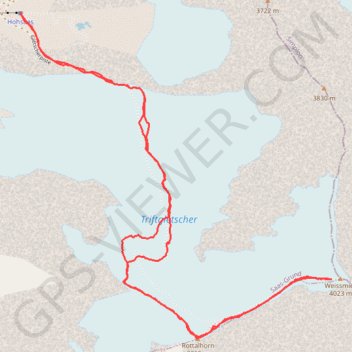
Weissmies
- Distance: 4.4 mi
- Elevation gain: 3,179 ft
- Maximum elevation: 13,097 ft
- Elevation loss: 3,179 ft
- Minimum elevation: 10,164 ft
Interactive trail map
Thank you for supporting this site ❤️
Make a donation
Make a donation
Gear up for your next adventure:
As an Amazon Associate, this site earns from qualifying purchases at no extra cost to you.
Trail profile
- Distance: 4.4 mi
- Elevation gain: 3,179 ft
- Maximum elevation: 13,097 ft
- Elevation loss: 3,179 ft
- Minimum elevation: 10,164 ft
Thank you for supporting this site ❤️
Make a donation
Make a donation
Gear up for your next adventure:
As an Amazon Associate, this site earns from qualifying purchases at no extra cost to you.
About this trail
Name: Weissmies trail, distance, elevation, map, profile, GPS track
End: Panoramaweg der 18 Viertausender, Saas-Grund, Visp, Wallis, 3910, Switzerland (46.13967 7.99110)
Coordinates: 46.12489 7.99110 46.13970 8.01146
Thank you for supporting this site ❤️
Make a donation
Make a donation
Gear up for your next adventure:
As an Amazon Associate, this site earns from qualifying purchases at no extra cost to you.