Make a donation
Gear up for your next adventure:
As an Amazon Associate, this site earns from qualifying purchases at no extra cost to you.
Echo Mountain
Interactive trail map
Make a donation
Gear up for your next adventure:
As an Amazon Associate, this site earns from qualifying purchases at no extra cost to you.
Trail profile
- Distance: 5.4 mi
- Elevation gain: 2,106 ft
- Maximum elevation: 3,189 ft
- Elevation loss: 2,106 ft
- Minimum elevation: 1,814 ft
Make a donation
Gear up for your next adventure:
As an Amazon Associate, this site earns from qualifying purchases at no extra cost to you.
About this trail
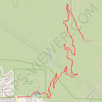
Name: Echo Mountain trail, distance, elevation, map, profile, GPS track
Coordinates: 34.20385 -118.13057 34.21530 -118.12074
Topography: Los Angeles County topographic map, elevation, terrain
Make a donation
Gear up for your next adventure:
As an Amazon Associate, this site earns from qualifying purchases at no extra cost to you.
Other hiking, mountain biking, running and outdoor activity trails
Click on a trail to view its statistics, map and profile.
Gabrielino Trail
United States > California > Los Angeles County
Starting from Chantry Flat, the Gabrielino Trail slips from the shaded ridge above Big Santa Anita Canyon into a classic Angeles National Forest corridor of wooded slopes, creekside cabins and canyon-bottom shade. The route passes the lower canyon junctions, Cascade Picnic Area and Spruce Grove Trail Camp…
Distance: 27.6 mi • Elevation gain: 7,736 ft • Maximum elevation: 4,662 ft
Dawn Mine Loop via Sunset Ridge Trail in Angeles National Forest
United States > California > Los Angeles County > Altadena
The Dawn Mine Loop Trail in the Angeles National Forest offers hikers a diverse and rewarding experience. The journey begins with a shaded ascent through Millard Canyon, where the lush vegetation and occasional stream crossings provide a refreshing start. As you approach the historic Dawn Mine, the trail…
Distance: 5.4 mi • Elevation gain: 1,988 ft • Maximum elevation: 3,596 ft
Echo Mountain via Lower Sam Merrill Trail
United States > California > Los Angeles County > Altadena
The hike to Echo Mountain via the Lower Sam Merrill Trail offers a blend of history, nature, and panoramic views of the Los Angeles area. As you ascend, you'll pass remnants of the old Mt. Lowe Railway, including the ruins of the Echo Mountain House, which was once a luxurious resort accessible only by incline…
Distance: 5.6 mi • Elevation gain: 2,467 ft • Maximum elevation: 3,189 ft
Make a donation
Gear up for your next adventure:
As an Amazon Associate, this site earns from qualifying purchases at no extra cost to you.
Dawn Mine, Millard Creek and Millard Falls
United States > California > Los Angeles County
Distance: 2.6 mi • Elevation gain: 285 ft • Maximum elevation: 3,051 ft