Make a donation
Gear up for your next adventure:
As an Amazon Associate, this site earns from qualifying purchases at no extra cost to you.
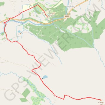
Walk up to Creag Liath
- Distance: 6.8 mi
- Elevation gain: 876 ft
- Maximum elevation: 1,375 ft
- Elevation loss: 1,001 ft
- Minimum elevation: 591 ft
- Moving time: 2 h 51 m
- Moving speed: 2.4 mph
- Maximum speed: 7.0 mph
- Total time: 3 h 45 m
- Global speed: 1.8 mph
Interactive trail map
Make a donation
Gear up for your next adventure:
As an Amazon Associate, this site earns from qualifying purchases at no extra cost to you.
Trail profile
- Distance: 6.8 mi
- Elevation gain: 876 ft
- Maximum elevation: 1,375 ft
- Elevation loss: 1,001 ft
- Minimum elevation: 591 ft
- Moving time: 2 h 51 m
- Moving speed: 2.4 mph
- Maximum speed: 7.0 mph
- Total time: 3 h 45 m
- Global speed: 1.8 mph
Make a donation
Gear up for your next adventure:
As an Amazon Associate, this site earns from qualifying purchases at no extra cost to you.
About this trail
Name: Walk up to Creag Liath trail, distance, elevation, map, profile, GPS track
Start: Trochry, Perth and Kinross, Scotland, PH8 0ED, United Kingdom (56.52993 -3.68464)
Coordinates: 56.51670 -3.69447 56.54167 -3.64844
Make a donation
Gear up for your next adventure:
As an Amazon Associate, this site earns from qualifying purchases at no extra cost to you.
Other hiking, mountain biking, running and outdoor activity trails
Click on a trail to view its statistics, map and profile.
Walk up Drumour and down Tombane
United Kingdom > Scotland > Perth and Kinross > Trochry
Distance: 5.8 mi • Elevation gain: 768 ft • Maximum elevation: 1,181 ft