Thank you for supporting this site ❤️
Make a donation
Make a donation
Gear up for your next adventure:
As an Amazon Associate, this site earns from qualifying purchases at no extra cost to you.
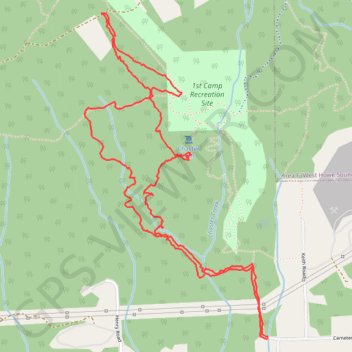
Loop hike to Chaster Falls
- Distance: 4.2 mi
- Elevation gain: 1,821 ft
- Maximum elevation: 2,116 ft
- Elevation loss: 1,827 ft
- Minimum elevation: 646 ft
- Moving time: 2 h 9 m
- Moving speed: 1.9 mph
- Maximum speed: 4.6 mph
- Total time: 2 h 36 m
- Global speed: 1.6 mph
Interactive trail map
Thank you for supporting this site ❤️
Make a donation
Make a donation
Gear up for your next adventure:
As an Amazon Associate, this site earns from qualifying purchases at no extra cost to you.
Trail profile
- Distance: 4.2 mi
- Elevation gain: 1,821 ft
- Maximum elevation: 2,116 ft
- Elevation loss: 1,827 ft
- Minimum elevation: 646 ft
- Moving time: 2 h 9 m
- Moving speed: 1.9 mph
- Maximum speed: 4.6 mph
- Total time: 2 h 36 m
- Global speed: 1.6 mph
Thank you for supporting this site ❤️
Make a donation
Make a donation
Gear up for your next adventure:
As an Amazon Associate, this site earns from qualifying purchases at no extra cost to you.
About this trail
Name: Loop hike to Chaster Falls trail, distance, elevation, map, profile, GPS track
Coordinates: 49.41759 -123.54332 49.43246 -123.53036
Thank you for supporting this site ❤️
Make a donation
Make a donation
Gear up for your next adventure:
As an Amazon Associate, this site earns from qualifying purchases at no extra cost to you.
Other hiking, mountain biking, running and outdoor activity trails
Click on a trail to view its statistics, map and profile.
Chaster Falls and Gibsons Creek Falls loop on Elphinstone Mountain
Canada > British Columbia > Sunshine Coast Regional District > Area E (Elphinstone)
Distance: 6.3 mi • Elevation gain: 2,169 ft • Maximum elevation: 1,880 ft