Thank you for supporting this site ❤️
Make a donation
Make a donation
Gear up for your next adventure:
As an Amazon Associate, this site earns from qualifying purchases at no extra cost to you.
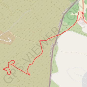
חורבת עמודה
Morning Trail Run
- Distance: 8.9 mi
- Elevation gain: 1,007 ft
- Maximum elevation: 1,302 ft
- Elevation loss: 994 ft
- Minimum elevation: 1,063 ft
- Moving time: 2 h 12 m
- Moving speed: 4.1 mph
- Maximum speed: 30.1 mph
- Total time: 2 h 42 m
- Global speed: 3.3 mph
Interactive trail map
Thank you for supporting this site ❤️
Make a donation
Make a donation
Gear up for your next adventure:
As an Amazon Associate, this site earns from qualifying purchases at no extra cost to you.
Trail profile
- Distance: 8.9 mi
- Elevation gain: 1,007 ft
- Maximum elevation: 1,302 ft
- Elevation loss: 994 ft
- Minimum elevation: 1,063 ft
- Moving time: 2 h 12 m
- Moving speed: 4.1 mph
- Maximum speed: 30.1 mph
- Total time: 2 h 42 m
- Global speed: 3.3 mph
Thank you for supporting this site ❤️
Make a donation
Make a donation
Gear up for your next adventure:
As an Amazon Associate, this site earns from qualifying purchases at no extra cost to you.
About this trail
Name: חורבת עמודה trail, distance, elevation, map, profile, GPS track
End: 35, Area C, Judea and Samaria, Palestinian Territory (31.59327 34.96163)
Coordinates: 31.56949 34.92267 31.59579 34.96194
Thank you for supporting this site ❤️
Make a donation
Make a donation
Gear up for your next adventure:
As an Amazon Associate, this site earns from qualifying purchases at no extra cost to you.