Whitelee Wind Farm, Scotland
Walk
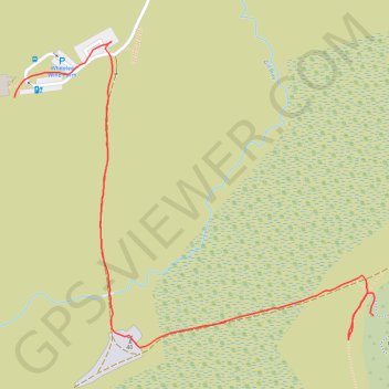
- Distance: 0.6 mi
- Elevation gain: 39 ft
- Maximum elevation: 968 ft
- Elevation loss: 72 ft
- Minimum elevation: 896 ft
- Moving time: 20 m 14 s
- Moving speed: 1.9 mph
- Maximum speed: 2.8 mph
- Total time: 31 m 52 s
- Global speed: 1.2 mph
Interactive trail map
Trail profile
- Distance: 0.6 mi
- Elevation gain: 39 ft
- Maximum elevation: 968 ft
- Elevation loss: 72 ft
- Minimum elevation: 896 ft
- Moving time: 20 m 14 s
- Moving speed: 1.9 mph
- Maximum speed: 2.8 mph
- Total time: 31 m 52 s
- Global speed: 1.2 mph
About this trail
Name: Whitelee Wind Farm, Scotland trail, distance, elevation, map, profile, GPS track
End: Outer Loop, East Renfrewshire, Scotland, G76 0QQ, United Kingdom (55.70979 -4.33605)
Coordinates: 55.70945 -4.34283 55.71271 -4.33603
Other hiking, mountain biking, running and outdoor activity trails
Click on a trail to view its statistics, map and profile.
Irvine, Scotland to Stonehouse and back
United Kingdom > Scotland > North Ayrshire > Irvine
Stonehouse, South Lanarkshire, Bike, Loop
Distance: 69.5 mi • Elevation gain: 3,668 ft • Maximum elevation: 991 ft