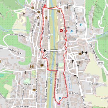
28/05/2022 17:14
- Distance: 1.4 mi
- Elevation gain: 69 ft
- Maximum elevation: 246 ft
- Elevation loss: 72 ft
- Minimum elevation: 177 ft
- Moving time: 28 m 55 s
- Moving speed: 2.8 mph
- Maximum speed: 9.8 mph
- Total time: 57 m 35 s
- Global speed: 1.4 mph
Interactive trail map
Trail profile
- Distance: 1.4 mi
- Elevation gain: 69 ft
- Maximum elevation: 246 ft
- Elevation loss: 72 ft
- Minimum elevation: 177 ft
- Moving time: 28 m 55 s
- Moving speed: 2.8 mph
- Maximum speed: 9.8 mph
- Total time: 57 m 35 s
- Global speed: 1.4 mph
About this trail
Name: 28/05/2022 17:14 trail, distance, elevation, map, profile, GPS track
Coordinates: 43.89794 10.68830 43.90527 10.69110
Other hiking, mountain biking, running and outdoor activity trails
Click on a trail to view its statistics, map and profile.
1 LUCENA - MONTPELLIER
Distance: 1,842.0 mi • Elevation gain: 96,785 ft • Maximum elevation: 3,438 ft