Make a donation
Gear up for your next adventure:
As an Amazon Associate, this site earns from qualifying purchases at no extra cost to you.
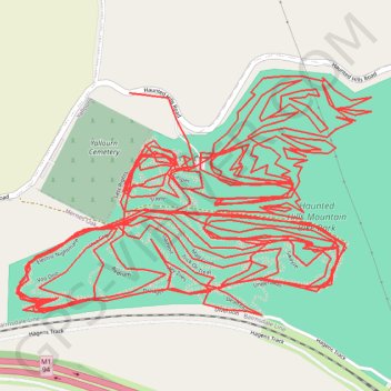
Every trail at Haunted Hills
- Distance: 22.6 mi
- Elevation gain: 2,782 ft
- Maximum elevation: 541 ft
- Elevation loss: 2,743 ft
- Minimum elevation: 341 ft
Interactive trail map
Make a donation
Gear up for your next adventure:
As an Amazon Associate, this site earns from qualifying purchases at no extra cost to you.
Trail profile
- Distance: 22.6 mi
- Elevation gain: 2,782 ft
- Maximum elevation: 541 ft
- Elevation loss: 2,743 ft
- Minimum elevation: 341 ft
Make a donation
Gear up for your next adventure:
As an Amazon Associate, this site earns from qualifying purchases at no extra cost to you.
About this trail
Name: Every trail at Haunted Hills trail, distance, elevation, map, profile, GPS track
Start: Backbone, Hernes Oak, City of Latrobe, Victoria, 3825, Australia (-38.19996 146.31650)
Coordinates: -38.20429 146.30997 -38.19771 146.32256
Make a donation
Gear up for your next adventure:
As an Amazon Associate, this site earns from qualifying purchases at no extra cost to you.
Other hiking, mountain biking, running and outdoor activity trails
Click on a trail to view its statistics, map and profile.
Traralgon - Walhalla - Woods Point
Australia > Victoria > Traralgon
#Bike
Distance: 77.4 mi • Elevation gain: 13,970 ft • Maximum elevation: 3,822 ft