Thank you for supporting this site ❤️
Make a donation
Make a donation
Gear up for your next adventure:
As an Amazon Associate, this site earns from qualifying purchases at no extra cost to you.
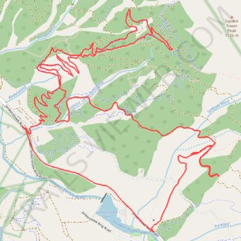
Jonkershoek Nature Reserve
- Distance: 9.6 mi
- Elevation gain: 2,490 ft
- Maximum elevation: 2,005 ft
- Elevation loss: 2,480 ft
- Minimum elevation: 787 ft
- Moving time: 1 h 55 m
- Moving speed: 5.0 mph
- Maximum speed: 28.7 mph
- Total time: 2 h 13 m
- Global speed: 4.3 mph
Interactive trail map
Thank you for supporting this site ❤️
Make a donation
Make a donation
Gear up for your next adventure:
As an Amazon Associate, this site earns from qualifying purchases at no extra cost to you.
Trail profile
- Distance: 9.6 mi
- Elevation gain: 2,490 ft
- Maximum elevation: 2,005 ft
- Elevation loss: 2,480 ft
- Minimum elevation: 787 ft
- Moving time: 1 h 55 m
- Moving speed: 5.0 mph
- Maximum speed: 28.7 mph
- Total time: 2 h 13 m
- Global speed: 4.3 mph
Thank you for supporting this site ❤️
Make a donation
Make a donation
Gear up for your next adventure:
As an Amazon Associate, this site earns from qualifying purchases at no extra cost to you.
About this trail
Name: Jonkershoek Nature Reserve trail, distance, elevation, map, profile, GPS track
Coordinates: -33.97770 18.93426 -33.95795 18.95531
Thank you for supporting this site ❤️
Make a donation
Make a donation
Gear up for your next adventure:
As an Amazon Associate, this site earns from qualifying purchases at no extra cost to you.